 |
| Tunnel View, Yosemite National Park |
Best known for its waterfalls, Yosemite National Park with its nearly 1,200 square miles is among the top ten most visited national parks in the US. Visitors not only come for the waterfalls though as evident in the variety of magnificent photos of famous rock formations, meadows and wetlands, lakes and rivers, viewpoints, giant sequioas, and the wilderness taken around Yosemite in different seasons throughout the year.
Our recent visit was already our second and still we have not covered even a quarter of all the natural attractions in this national park. That means more opportunities to go back and admire its beauty over and over again, in another season probably.
How to get there:
Yosemite National Park can be accessed from five main gateways.

West Gateway - Hway 140
Famous for its natural beauty and for being driver-friendly, this gateway is always open and provides access to Yosemite National Park (starting from Merced) year-round.
If you're coming from San Francisco or Bay area
Distance: 195 mi / 314 kmTime:4-5 hours
Take I-580 east to I-205 east to Highway 120 east (Manteca) or Highway 140 east (Merced) into Yosemite National Park.
From Sacramento
Distance: 176 mi / 283 km
Time: 4 hours
Take Highway 99 south to Highway 120 east (Manteca) or Highway 140 east (Merced) into Yosemite National Park.
North Gateway - Hway 120
An alternative gateway if you are coming from San Francisco or Bay area by taking I-580 east to I-205 east to Highway 120 east (Manteca) into Yosemite National Park. Approximately the same travel time from Hway 140.
From Lake Tahoe and Reno
Approximately June through October, conditions permitting
Distance: 218 mi / 351 km (Reno)
Time: 5 hours
Take US 395 south to Lee Vining; take Highway 120 west into Yosemite National Park (open late May/June through October, depending on conditions)
Time: 5 hours Take Highway 190 west to US 395. Take US 395 north to Lee Vining; take Highway 120 east into Yosemite National Park (open late May/early June through October, depending on conditions).
Distance: 218 mi / 351 km (Reno)
Time: 5 hours
Take US 395 south to Lee Vining; take Highway 120 west into Yosemite National Park (open late May/June through October, depending on conditions)
From Death Valley National Park
June through October
Distance: 270 mi / 435 kmJune through October
Time: 5 hours Take Highway 190 west to US 395. Take US 395 north to Lee Vining; take Highway 120 east into Yosemite National Park (open late May/early June through October, depending on conditions).
From Las Vegas
June through October, conditions permitting
Distance: 400 mi / 642 km
Time: 8 hours
Take US-95 North to Tonopah, then US-95/US-6 west to Highway 120. Go west on Highway 120 into Yosemite National Park (open late May/early June through October, depending on conditions).
June through October, conditions permitting
Distance: 400 mi / 642 km
Time: 8 hours
Take US-95 North to Tonopah, then US-95/US-6 west to Highway 120. Go west on Highway 120 into Yosemite National Park (open late May/early June through October, depending on conditions).
John Muir - Hway 132
Provides a more scenic and laid back route to the North Entrance. It follows the Toulumne River from Modesto turning left at the intersection of Hway 132 and 49, passing through Coulterville (one of the most unspoiled Gold Rush towns).
Provides a more scenic and laid back route to the North Entrance. It follows the Toulumne River from Modesto turning left at the intersection of Hway 132 and 49, passing through Coulterville (one of the most unspoiled Gold Rush towns).
South Gateway - Hway 41
The southern entrance brings you to Yosemite through Madera or Mariposa via Wawona. You can stop by Mariposa Grove Museum (currently closed for restoration until 2017). You will also be passing by Tunnel View, a great introduction to what natural beauty there is to see, before reaching Yosemite Valley.
From Los Angeles area
Distance: 313 mi / 504 km
Time: 6 hours
Take I-5 north (or I-405 north to I-5) to Highway 99 north to Highway 41 north (Fresno) into Yosemite National Park.
Distance: 313 mi / 504 km
Time: 6 hours
Take I-5 north (or I-405 north to I-5) to Highway 99 north to Highway 41 north (Fresno) into Yosemite National Park.
From San Diego area
Distance: 441 mi / 710 km
Time: 8 hours
Take I-5 north to Highway 99 to Highway 41 north (Fresno) into Yosemite National Park.
From Las Vegas
November through May
Distance: 495 mi / 797 km
Time: 8-10 hours
Take I-15 south to Barstow; Highway 58 west to Bakersfield; take Highway 99 north to Fresno. In Fresno, take Highway 41 north into Yosemite National Park.
From Death Valley National Park
November through May
Distance: 450 mi / 720 km
Time: 9 hours
Take Highway 190 west to US 395; take US 395 south to its junction with Highway 14. Take Highway 14 south to Mojave. In Mojave, take Highway 58 to Bakersfield. From Bakersfield, head north on Highway 99 to Fresno. In Fresno, take Highway 41 north into Yosemite National Park.
East Gateway - Hway 120 from Hway 395
This is another alternative route/entrance for those coming from Las Vegas (across Death Valley National Park), from Reno, or from Los Angeles (with option to stop at Mammoth Lakes). Do take note that this is route is usually open only in late spring/early summer until late fall. Tioga Pass Rd usually closes during fall and winter season due to snow.
Hway 395 is a scenic route with beautiful vistas of the Eastern Sierra Nevada mountains. You can stop by Mono Lake for its tufa towers (limestone formations).
When we came in 2003, we came from Sunnyvale, California and drove to Yosemite very early in the morning for a full-day visit. We took the North Gateway via Hway 120. This time around, we decided to book our accommodation closer to Yosemite to have shorter driving distance and spend more time exploring the park. We took the West Gateway via Hway 140.
Entrance fee:
- Seven-day pass > Non-commercial car, pickup truck, RV, or van with 15 or fewer passenger seats
US$30 per vehicle (no per-person fee)
(the fee is only US$25 from November through March) - Yosemite Pass: US$60
Annual pass providing free entrance to Yosemite for 12 months from the date of purchase - America the Beautiful—National Parks and Federal Recreational Lands Annual Pass: US$80
Annual pass covering entrance and standard amenity fees for national parks and other federal fee areas. This replaces the National Parks Pass and Golden Eagle Pass.
Since we intended to visit more than 3 national parks, it was more cost effective for us to get the America The Beautiful Annual Pass. We saved about US$45.
Places to stay:
There are a variety of options to choose from within Yosemite itself. There are camping grounds, RV camping areas, tent cabins and lodges, the choice is yours. If you prefer to stay in the park, you can choose from the options listed in this link: http://www.travelyosemite.com/lodging/yosemite-lodging-experience.
If you prefer to stay outside Yosemite but still within a short driving distance away, there are a number of inns and hotels in the areas surrounding Yosemite. The list of accommodations can be found in this link: http://www.yosemite.com/where-to-stay.
We chose to stay around Mariposa, California which was about an hour drive to Yosemite and booked our accommodation via booking.com. I have chosen Miners Inn because of its affordability (USD157 for a queen room with 2 queen beds) given that it offered free parking, free wifi and free breakfast included in the room price. It is located along CA-49 (Golden Chain Hway) and the check in counter was in the first building to the right (upon turning into the Yosemite Miners Inn driveway). We had a big, comfortable room and clean bathroom.

Here are more info about our accommodation.
Their business card says it all.

 |
| the color of autumn which greeted us early morning while on our way to have breakfast |
 |
| Here we were having a hearty breakfast. We made our own waffles which Ira liked a lot. We also had some fruits and a variety of pastries. Chocolate drink and some juice,too. Heavy breakfast for a full day of walking around Yosemite National Park. |
What to see and do and our experiences, too!
From Miners Inn, we drove to the West Gateway entrance via Hway 140 to Yosemite National Park. That was about 45 minutes drive. We realized this really wasn't the same way we entered the park before as the road was not that familiar. There were not as many zigzags and we were not high up the mountain (confirmed, we were on Hway 120 then).
We bought the America the Beautiful Annual Pass from the entrance which came with a park map and the recent park guide.

The park pass is the same size as a credit card. It has to be signed by the passholder with valid photo ID (in our case, it was my husband since he was driving). A hole is punched on the month when the pass is bought, which is indicated at the back of the pass. It also states the year of expiration. This was our ticket to all the national parks we have visited during this trip.

The guide and the map are the two most important materials you will need in any national park exploration (second to the entry pass). The Yosemite Guide lists down the seasonal highlights so visitors know what activities are available and what attractions are there to see.

The park map gives an overview of the immense size of Yosemite. The distance you can cover, the number of attractions you can see and the adventures you can have all depends on the amount of time you want to spend in this breathtaking national park. We saw almost the same places from the time we've first visited but it was during a different season. I'd say it was like visiting a different national park altogether because we got to see another side of nature that we didn't see before. That's the beauty of having four seasons.


Armed with useful tools for our first national park exploration during this road trip, we continued our drive along the narrowing road until we approached the Arched Rock Entrance. We had to slow down and wondered if our car could fit in between the two boulders leaning on each other. We wanted to take a photo of it but cars were approaching behind us and we didn't want to cause any traffic jam.
 |
| Here is how the Arched Rock Entrance looks like. Photo credit to Google Maps |
Our car did fit after all and we drove along El Portal Road (one way road) for about 10 minutes until we saw signs towards Tunnel View. We turned right and crossed the Pohono Bridge over the Merced River. Then, bearing right, we followed the road and turned right to CA-41 going to Wawona/Fresno. From there, it was just about 3 minutes until we reached our destination.
We arrived at TUNNEL VIEW at around 930am, early enough not to have too many tourists crowding around the vista point. We almost had the place to ourselves for a good 30 minutes or so.
TUNNEL VIEW, with expansive views of Yosemite Valley, El Capitan, Bridal Veil Falls and Half Dome, is a good introduction to what lies waiting to be seen at Yosemite National Park. When you talk about scenic vistas this is the place to be.
 |
| Tunnel View through our camera lens: with the colors of autumn on the valley, Bridal Veil Falls on the right, El Capitan on the left, and farther away is the Half Dome |

This was what I meant by less crowded. We didn't need to tiptoe or muscle our way to get a full view of the scenic vista nor wait for a long time for our turn to pose and take photos (solo, couple, family). We had this place all by ourselves so there was no rushing. We took our time soaking in the breathtaking view.


 |
| Kelvin directing Ira on how he wanted the shot to be taken |
We were there for about an hour, finally satisfied with taking in the view and taking photos, too. It was about time we leave as other cars arrived, one by one, and the area started getting packed. We were supposed to go down to Yosemite Valley but somehow took the road going into the tunnel which was on the way to Wawona and Mariposa Grove. We realized we were going on the wrong direction when the road continued to zigzag up the mountain. My bad, as the navigator, I should have figured it out much sooner. I even actually dozed off while my husband decided it was time to turn back.
When I woke up we were parked at the side of the road (Wawona Road) overlooking another scenic spot in Yosemite. This vista point was about 1.6 miles from the end of the tunnel which we passed by coming from Tunnel View. There were several other cars parked on the road side while passengers came out to take more photos of yet another breathtaking view.

It was about 1130am when we stopped for this photo op.

From Wawona Road we made our way down to the Yosemite Valley passing by Bridalveil Falls first. It was about 1.6 miles away to the parking lot which was the launching point for the trail to the falls. The Bridalveil Falls trail was about 10 minutes walk from the parking lot (about 0.2 miles of paved trail). But then again, it depends on how fast you walk and how many stops you make along the way, specially if you have kids who like to play in the woods or in the water. Some parts of the trail also gets steep as you get closer to the base of the waterfalls.
Bridalveil Falls is one of the famous falls inside the park. It was the first waterfall we've seen in this visit to Yosemite, and it usually is the first waterfalls that visitors see upon entering the park. It can be viewed from the main road and, if you are adventurous enough, you can get closer by climbing up boulders to get to the waterfalls landing.


 |
| Here we were at the base of the waterfalls. This was the starting point of the thrilling climb up closer to the waterfalls. |


This type of adventure is what appeals to Ira (with all the energy that he has to burn). He loved going up and down the boulders and was leading the way. When it came to higher or wider steps we had to give a little assistance, only as much as he would allow us. We told him that we didn't really need to reach the top but he seemed to be determined to get there.
 |
| Giving him a little push and support as he climbed up this steep boulder. Thank goodness for hiking shoes which made it a lot easier to climb and not slip through wet rocks. |
 |
| weaving his way around those boulders |
He told us that he really wanted to get those colourful rocks he saw in the hotel souvenir shop. They were said to have been taken from the plunge pool . We said there probably aren't any more of those beautiful colored rocks left. He finally caved in and we settled on a spot (ok, maybe two) where we could have family photos, yet again.
 |
| with the Bridalveil Falls behind us This spot was perfect even for bigger groups as the boulder can accommodate more people. |
 |
| This shot was a bit challenging to take. Just below us was a pool of water and we had to leap to get to where we were. It was no problem for Kelvin and my husband with their slightly longer legs. Ira needed assistance and a little push and so did I. Then we had to hold this pose until we hear the clicking sound from the camera. Talk about adventures! |

If it was slightly easy going up, the going down part was a bit tricky. We took a different route on the way back, following some of the climbers in front of us who seemed to know better. Then we got into the spot where we had to make our way down, stepping into a narrow gap with a boulder on the left and. with one misstep, the possibility of falling down on the right side. There was another option to turn back and go the other way, but that meant we had to go around and back to where we were. After looking at the other climbers zoom past safely, we decided we could also do it with proper caution.
 |
| this was me taking the lead, a bit nervous but concentrating on the fact that I should be able to make it because I need to be the one assisting the 3 others following after me |
 |
| then it was Ira's turn... He had to be more careful since his legs were shorter than mine. I had to point where he should put his feet to be able to go down safely. |
 |
| Kelvin was big enough to handle things on his own. I just had to tell him where to step then I was back to checking where Ira was going to. |
We spent about an hour walking along the Bridalveil Falls Trail, climbing boulders, taking photos, resting while looking at the waterfall and making our way back to the parking lot. We even made a stop at this spot where the water was flowing and this big rock which seemed to be perfectly in place for a good family photo op.
 |
| It's not often that we see flowing water as clear (and cold) as this. An opportunity for the boys to play in the water and wind down from the adrenaline-pumping climbing activity we just had. |
From Bridalveil Falls parking lot was a short drive to where we were face to face with the largest exposed granite monolith in the world - EL CAPITAN. Towering more than 350 stories above Yosemite Valley, this behemoth is difficult to miss as you drive along Southside Road coming from Bridalveil Falls. It's a given specially seeing the number of vehicles parked along the road as visitors came out to have a full view of El Capitan.
 |
| the road was clear of traffic so we were able to take this shot |
After photo-taking, we were back in the car and drove along Southside Drive which was lined with trees for about 3 miles to make another stop. Immediately after the trees have cleared you will see Yosemite Falls. The last time we were here we also stopped to take a family photo. This time around, there was more to just photo-taking.
 |
| a glimpse of Yosemite Falls from afar |
We went to the left side first to have a look and take a photo of Yosemite Falls from afar, recreating (sort of) our shot from a decade ago.


We went down, careful with our steps as the road was icy and slippery. On the left side of the road was dry grass, a little bit of snow on the ground and Yosemite Falls on the background. The right side of the road was covered with thicker snow piles and was winter heaven for the kids playing around.
Then the boys started their snowball fight....


There was not enough snow to make big snow balls on this side of the road so we crossed over to the right side for more snow play. The snow pile there was way thicker that our feet sunk for about a foot!
 |
| guess what this chunk of snow pile looks like? |
 |
| their piles of snow getting bigger by the minute |

Actually, someone left this standing for others to complete or take photo with. So nice of them to share their hardwork with others. We added some twigs for the mouth.


We spent another hour playing in the snow before driving to Yosemite Village. We made a quick stop at the Yosemite Chapel which was just 0.2 miles away. While the boys waited in the car, hubby and I took some photos of the chapel.

By 3pm, we made our way to the Yosemite Village visitor parking lot driving along Southside Drive turning left on Sentinel Drive then right on Northside Drive. There were signs directing visitors to the big parking lot. We had to drive very slowly because of the snow-covered road, some parts of the parking lot even had hardened snow (ice) that it was too slippery to walk out of the parking lot.
 |
| on our way to the Village we had this view of the Half Dome |
We walked across the parking lot to the Village Store to grab some late lunch. We bought pasta and cold sandwiches and some chips. We ate just outside the store where there were tables and chairs for visitors.

 |
| someone left this cute snowman outside the shop |
After eating, we made our way, on foot, to Yosemite Falls. We took the 1 mile scenic route along Village Drive following the signs leading to the falls.

We have been to Yosemite Falls before but we couldn't remember passing through this way. We thought we had a shorter walk before.
 |
| we couldn't resist taking a photo of this stop sign as it was the shortest we have ever seen. We wondered whom this sign was for... |
 |
| this tepee was just outside the museum |
 |
| Kelvin in the same tepee 12 years after |
 |
| look how tall he is now! |
 |
| 2003: Kelvin was 3 years old 2015: Ira was 11 years old |
 |
| trying to measure how big this tree was |
On our walk to the falls we passed by this area where we had another view of Half Dome. There were even a few deer grazing while we took this photo. Unfortunately, there were not in this photo with us.

There was so much to see along the way and the boys thought about dozens of things to do with the nature that was around us.

Kelvin saw this fallen tree and immediately went to it. He dared himself to cross the log, at first feeling a bit hesitant. I cheered him on and said that he could do it and if ever he falls he was tall enough to jump and not hurt himself in the process.
 |
| Ira couldn't get over the fact there there was this plant growing on the side of the tree and was blocking his way and distracting his concentration. He also pointed out that the log was quite slippery and there definitely was a big probability of him falling down. |
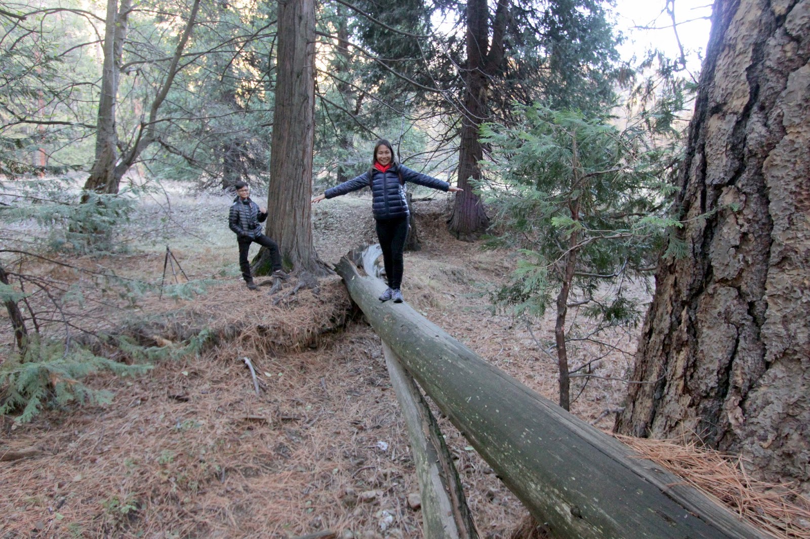 |
| I tried a different approach and walked from the other end of the log. But, like Ira, I also didn't quite make it to the other end. My nerves got the better of me. |
 |
| as we were walking along, we saw several logs on the ground and thought we could practice on them since there was no danger of us falling from up high |
The hike we made from the parking lot to the Yosemite Falls provided a lot of opportunities for the boys to explore the great outdoors. We had fun and didn't notice we were already tired until we got to the bridge where we could see the falls up close.

We finally made it! The area didn't seem familiar although we knew we've seen the bridge before. There has been some changes since we came here in 2003 (or so we thought).


Photo above: taken in 2015 (fall)
Photo below: taken in 2003 (summer)

We could hear the thunderous flow of water down from the top of the mountain. Ira said he wanted to climb up the boulders again to get closer to the waterfall. So we looked for a trail and followed some of the visitors who were already making their way up.
 |
| we settled on this group of rocks, brought out our snacks and had a picnic It was also a good time to rest our feet and legs from all the walking and climbing. |
 |
| a view of Half Dome from the bridge as the sun was setting |
 |
| before sunlight was totally out of sight, we slowly made our way back to the parking lot. We sort of underestimated how fast it was to get dark during fall/winter. It was already too dark when we were making our way out of the woods. We didn't have any flashlights with us because we didn't really plan to be out in the wild at this time. We were glad no bears nor snakes showed up. |
The places we've been to and sights we've seen are just some of the attractions of Yosemite National Park. There are still a number of hiking trails, waterfalls, lakes, mountains to climb and wilderness to explore.
A visit once is definitely not enough. Twice still does not allow you to cover that much. That means you can visit the park over and over again, at different seasons, and you will always be wowed by the experience. I knew we were.
Website: For a list of more things to see and do, visit:
Travel Tips:
- Wear comfortable hiking or walking shoes. There will be a lot of walking to do.
- Although there are shops in the village, I suggest you bring your own food specially if you want to have a picnic in any of the picnic areas within the park. Make sure you keep your food secure and follow park rules when it comes to storing food. Remember: BEARS can tear your car apart.
- If you are visiting during summer, HYDRATE. Bring water bottles with you.
- Park your cars in the designated parking lots and walk or take the shuttle around the park. This is highly recommended specially during summer when a bigger group is expected to visit. The last time we were in Yosemite is around summer and the parking lot was FULL. Those who arrived after 9am had to park along the road leading to the village. That meant a whole lot of walking.
- Bring a camera to take those memorable snapshots BUT don't forget to personally experience the nature at its best.
Hope you enjoyed reading my blog on our Yosemite visit. The road trips to Monterey, Solvang, Los Angeles and other national parks are coming up soon. We're only in Day 5 so do come back for more stories of our 21-day road trip in the US.
No comments:
Post a Comment
Please feel free to LEAVE A MESSAGE, ASK A QUESTION or SHARE YOUR EXPERIENCES, too. I would love to hear from you