 |
"Hiking is a bit like life:
The journey only requires you to put one foot in front of the other... again and again and again. And if you allow yourself opportunity to be present throughout the entirety of the trek, you will witness beauty every step of the way, not just at the summit." - Unknown
|
Day 13 was one of the most exciting day of our trip because we looked forward to one of the most famous and thrilling hikes in all of USA's national parks. We've seen pictures and watched videos of visitors who made it to the top and we knew we could do it, weather permitting. So here's what our day was like at Zion National Park....
I mentioned in the previous blog that it was already night time and dark when we arrived the night before, and that the colorful Christmas light up along the streets and in the different establishments and houses were a warm welcome scene emerging from the darkness of the national park area. The following day we were more amazed by the sight that greeted us on a cold winter morning.
 |
| view from our room balcony overlooking the Zion National Park rock formations. Yeah, we were that close and it was one of the reasons why I chose for us to stay at Bumbleberry Inn |
Destination: BUMBLEBERRY INN
Address: 97 Bumblerry Lane, Springdale, UT 84767
Website: http://www.bumbleberry.com
Points of Interest: The picture above about says it all as a destination. With great views of the Zion National Park to welcome you every morning, what more could you ask for? The Inn also has a petting farm with mini ponies wandering around and ducks swimming in the pond. There's a pool, unfortunately, it was closed during our visit, though that didn't dampen our spirits by one bit.
 |
| caught the couple of ponies grazing in the morning |
 |
| our hiking shoes all ready for the day's adventure |
Our stay at Bumbleberry Inn came with free breakfast at the Wildcat Willies Ranch Grill Saloon which has a Southwestern theme. The staff were just beginning to put up the Christmas tree and hanging the festive decors on the morning we had our first breakfast there.

All geared up on the cold winter morning, sipping our hot chocolate drinks while waiting for each of our chosen breakfast meals to be taken to our table. The logos on the cups made us even more excited for the hike we were taking that day.

There were a variety of breakfast options to choose from and here were our favorites:
 |
| Willies Pancakes for the little one. You can never go wrong with pancakes for someone who's a picky eater. |
I had BAJA SUNRISE - two eggs sunny side up served on Masafina tortillas with black beans and homemade enchilada sauce, topped with queso fresco, pico de gallo, scallions, black olives, avocado, sour cream drizzled with tomatillo salsa. That was pretty heavy and definitely woke me up.


Kelvin had Willies French Toast - French bread dipped in a scrumptious mixture of eggs, milk, vanilla, orange zest, cinnamon and nutmeg - and Mark had THE MILE-HIGH 3 EGG OMELETTE with ham, red and green bell peppers, onions and four-cheese blend accompanied by breakfast potatoes and toast. We enjoyed these highly recommended meals which fueled us on our hike.
After breakfast, we walked around to check out the gift store first. There were so many interesting items to choose from but we postponed the shopping till after we came back from our hike.
From Bumbleberry Inn, we drove off to Zion National Park visitor centre which was just about 1.5 miles away. It was a very different scenic drive from what we'd seen the night before. The night skies were now bright blue. The surrounding darkness were now filled with colorful, majestic rock formations. We were actually happy we made the decision to go on a fall/winter trip because the national parks were not too crowded with visitors, parking was not a problem at all and we got to enjoy nature almost by ourselves at times.
Destination: ZION NATIONAL PARK
Address: Utah 84737, USA
Getting there: Zion National Park is located at State Route 9 in Springdale, Utah. It has three main entrances:
- East Entrance - via US-89 to the U-9/Zion-Mt Carmel Highway. This 1.1 mile long Zion-Mt Carmel tunnel leads to the Zion Canyon Scenic drive where some of the most popular landmarks in the park can be seen. This was where we drove through on a very dark night on our way to Bumbleberry Inn.
- South Entrance - accessed via Springdale. Where the Zion Canyon Visitor Center and Museum are located. Perfect stop just before you explore the park to get helpful guide brochures and newsletters. This was the entrance we used to get into the park on Day 13.
- Kolob Canyon Entrance - in the park's northwest border, located 18 miles from Cedar City; take I-15 to exit 40. Kolob Canyon also has winding roads and miles of trades like that of Zion Canyon but not as crowded. Kolob Canyon Road may be closed from November to mid-April.
That saying, we've passed through two of the three entrances in less than 24 hours!
Aside from driving to the park, there are also FREE SHUTTLE SERVICES. Park visitors are required to take the shuttle during peak tourist season (April to October). Visitors can board the shuttle from Springdale. The shuttle runs along the six-mile Zion Canyon Scenic Drive and stops at all major trail-heads and landmarks.
Bicycles are allowed on established roads and on the Pa'rus Trail but NOT on the Zion-Mt Carmel Tunnel.
Cost:
US$12 per person (valid for 7 days)
US$25 per vehicle (valid for 7 days)
US$50 annual pass (valid for one year from month of purchase)
US$80 America the Beautiful National Parks and Federal Recreation Land Pass (valid for one year from month of purchase) -- we purchased this to cover for all the entrance fees of the parks we've visited. It's great value for money!
Permits for ALL overnight back-country hiking and camping (REQUIRED)
US$5 for up to twelve people
US$10 escort fee for over-size vehicles travelling through Zion-Mt Carmel tunnel
Points of Interest: There
Experiences to share:

We stopped by one of the first parking spaces to take a family photo while it was only us in the ground. Then equipped with a map and some brochures from the visitor center, we continued along Zion Canyon Scenic Drive until we reached the Grotto Picnic Area.

We parked across the road overlooking the Virgin River and geared up for outside temp which was freezing cold. We carried backpacks filled with energy food (which means chocolates and some bread and chips) and bottles of water to sustain us for the duration of our hike. We crossed the wooden bridge which lead to the Emerald Pools trail and West Rim trail. It was tempting to go for the Emerald Pools but we had our eyes on Angels Landing. We decided if we still had time and energy after conquering the summit, then we would go have a look at Emerald Pools.

I think we must have taken photos at almost every turn and stop that we made which was great to look back to. In the above photo, we just started on the West Rim trail which was the beginning few miles of the hike up Angels Landing.

True to what was stated in the brochures and websites, it was a steady, uphill hike for about 2 miles in paved, well-maintained trail. It was easier when we were still closer to the floor of the valley but as we slowly made our way higher we could feel gravity pulling on us (literally). We stopped several times to catch our breath and have some chocolate bites (that's for me) while Ira walked way ahead of us and didn't seem to mind the steep climb,
 |
| here he was patiently waiting for us for minutes |
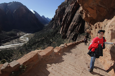 |
| the flat trails became staircase steps as we got higher and higher into the series of switchback trails up the Refrigerator Canyon |

We found an interesting shallow cave, if we could call it that, along the way and couldn't resist to have a photo taken with it and in it. As you may have observed, we have stripped off our winter gear as we felt hotter and hotter the higher and farther we were.

 |
| and when we thought we were already done with the switchbacks, here came another series of them. Called Walter's Wiggles, these switchbacks (all 21 of them) are very tight which enables hikers to gain height rapidly (and lose breath rapidly, too!). This part of the hike was the most challenging for us, I
think. As you can feel how steep the incline was, you can only hope you can walk as fast as you can
to gain momentum and reach the top as quickly as you can. Then again, because it's steep, you haveto be careful with your steps so as not to trip and roll back all the way down. |

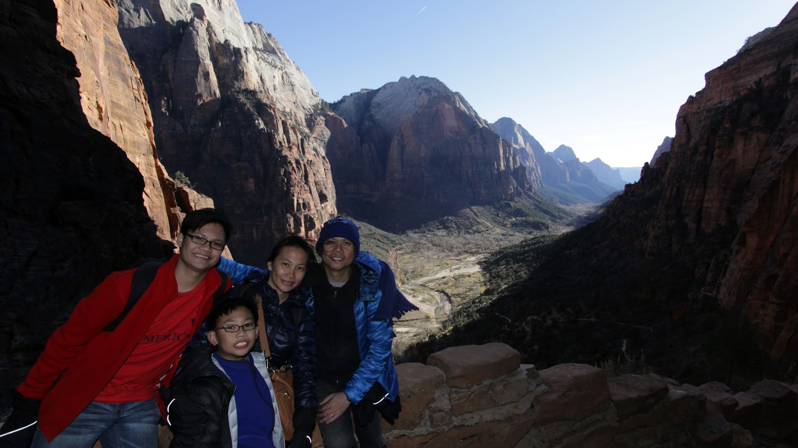
It was such a relief to finally be done with Walter's Wiggles and be at the top of Scouts Lookout which was the final jump off point to Angels Landing. There we got to rest our feet and have some snacks before walking the final half mile up. Scouts Lookout is also has restrooms but no drinking water.
The view from up here was amazing and gave us a feeling of achievement looking down to where we've been. We've come a long way and we felt good we managed to do get here and still had smiles on our faces. We were looking at the remaining part of the hike and decided we should get going while the sun was still up so we could enjoy the view even longer when we were up there.
 |
| the boys reading the Angels Landing caution signage |
After reading about death of hikers from years ago, Ira got really nervous and had second thoughts about doing the final half mile. We encouraged him and told him we were already there so might as well finish what we'd started. We said we'd go as far as we could as long as we felt safe and comfortable with it. So we continued our hike but this time around we had the help of chains as we scaled the rock edges.


Steep climb up to get the the final launching point to Angels Landing. Ira was getting the hang of it and his nerves had calmed. I was the one getting anxious as I watched him make his way up. Thanks to the hiking shoes we wore cause they made the hike a little safer with better traction/grip and more comfortable to the feet.

They call this part of the hike the Hogsback.

My husband continued to take photos of almost every step. These photos were taken using a DSLR camera and not an attached Go Pro unit so you can just imagine how he would stand precariously at the edge of a rock or holding on to the chains.

 |
| and this part was where you separate the determined and brave from the onlookers :) |
Looking at the path leading to the ascent up Angels Landing, we could see a very narrow walkway lined with chains with steep drops on either side. Looking up, we could see hikers making long strides to get to the next step. We were now doubting the idea that Ira could make it all the way across and up the Landing. We read about 9-year-olds doing this hike and we assumed he could do it, too. We wanted to know how difficult the hike really was so we asked a hiker who just went down from the Landing and was resting by the bushes. He said it actually was not that difficult because there were chains to hold on to and the pathway was pretty much easy to follow but there were some steps which were too high and Ira may have difficulty reaching them and he wouldn't be too confident moving on.
 |
| we let Ira try the first hurdle before getting to the double drop zone and it looked like it would be a big challenge for him to go through the rest of the way. We had to help lower him to get to this part and then carefully push him up to get back to the top. We decided he'd have to sit this one out and Daddy had to stay with him. |

And so it was just Kelvin and me, mother and son bonding to the top. I'd have to say this first few steps until we got across the double drop were the most difficult ones to make. My mind was working overtime thinking of all possibilities and guarding against falls or slip ups. I was leading the way in the first half of our ascent, making sure that the rocks I'm stepping into were stable enough for Kelvin to follow.
 |
| this part was like a walk in the park. Although we were already higher, the drop on the side was not as steep and the path was easy to follow. |
 |
| at this part, the pathway became more narrow and there were times when we couldn't clearly see where the next step should be. We let some of the other "experienced" hikers to take the lead and point out the proper/safer path to take |
 |
| Kelvin's long legs were very useful in this part of the climb. He breezed through it while I slightly struggled taking smaller strides than him |

 |
| almost there... waiting for our turn to go up the steps while making way for the others to go down |
 |
| one final push and we were encouraged by other hikers who had already been enjoying the views from the top |
 |
| and we made it! We found a spot where we could sit, gather ourselves (and our shaken nerves) and soaked in the view. |
 |
| this was one exhilarating experience I'm glad I got the chance to do with my son |
 |
| looking down at the valley floor, I almost couldn't believe we've made it to the top |
Truth be told, I wanted to take more pictures from up there but I was too scared to drop the phone as my hands and knees were still shaking (I think). Adrenaline-pumping experience I'd never forget.
We waived at Daddy and Ira who were patiently waiting and taking our photos.
 |
| what comes up must go down... and so we made our way down after resting and catching our breath |
 |
| going down was much easier and faster than coming up |
 |
| was this path man-made or natural? Sits perfectly in the middle. |
 |
| this photo makes it look scary and dangerous |
 |
| Ira was having fun walking around stepping on rocks |
 |
| and there we were, making it back through the threshold |

 |
| going through his own little adventure across Angels Landing |
 |
| hiding from the sun |


 |
| me and my boys on this great hike at Zion National Park. We sat down for sometime, had some snacks (and yes, we kept our trash with us), enjoyed the view before we made our way back to the valley floor |
 |
| being there actually doesn't feel that much scary maybe because the big drop was behind us. Or was it the chains? Or were we just brave enough? Only making a second trip there will determine. |
 |
| Thumbs down for those who didn't make it, and a big thumbs up plus huge smile for those who made it to the top |
 |
| there will always be a second time and we're prepping Ira for that! |
 |
| thumbs up means they're going to try it again next time - successfully! |
 |
| walking down the Wiggles... that's how steep it was! |
 |
| the look on our faces says it all |
 |
| still a long way down to the parking lot where we came from |
 |
| one way of really appreciating the effort we made going on this hike was looking at this photo and realizing yeah, we've come this far. We broke a sweat. We stopped several times. We huffed and puffed. And although we didn't reach the top of Angels Landing as a family, we did make it this far and it was a great bonding experience. We are definitely doing this again! |
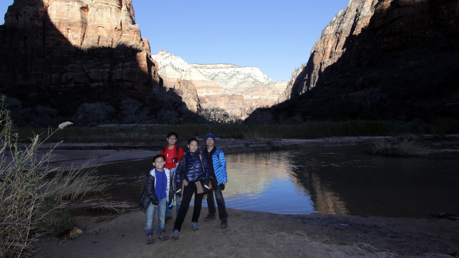 |
| stopped by the riverside |
 |
| he's in his element again |
 |
| it would have been nice to run around and get our feet wet if the water wasn't freezing cold |
 |
| he specifically picked this up because it looked like a potato |
 |
| just beautiful as the sun went down |
We did it! We conquered Angels Landing - all 8.7kms of trail, with its winding paths, its steep uphill sections, the switchbacks and the final stretch of long drop-offs till we got to the top of the 1488ft tall rock and back to the carpark. Our day was still not over though as we planned to go back to the park at night for stargazing.
For hiking enthusiasts, here are other trails to explore which I arranged based on shuttle stops for easier navigation (we will be referring to this one on our next trip!):
Shuttle Stop#1 - Zion Canyon Visitor Center
Easy trails
- PA'RUS TRAIL - about 2hrs roundtrip (5.6km trail); paved trail
- ARCHEOLOGY TRAIL - half an hour hike (0.6km trail); short but steep; trailside exhibits
Moderate Trails
- WATCHMAN TRAIL - 2hrs roundtrip (4.3km trail); moderate drop-offs; ends at viewpoint of the Tower of the Virgin, lower Zion Canyon and Springdale
Shuttle Stop#5 - Zion Lodge
Easy Trails
- LOWER EMERALD POOL TRAIL - shuttle stop #5 (Zion Lodge); an hour roundtrip (1.9km trail); paved trail with minor drop-offs
Moderate Trails
- SAND BENCH TRAIL - 5hrs roundtrip (1r2.2km trail)
- UPPER EMERALD POOL TRAIL - 1hr roundtrip (1.6km trail); minor drop-offs; sandy and rocky trail
Shuttle Stop#6 - Zion Lodge / The Grotto
Easy Trails
- THE GROTTO TRAIL - shuttle stop #6 (Zion Lodge / The Grotto); half an hour roundtrip (1.6km trail); can be combined with Kayenta and Lower Emerald Pool trails to create a 2.5mile loop
Moderate Trails
- KAYENTA TRAIL - 1.5hrs roundtrip (3.2km trail); moderate drop-offs; unpaved climb to Emerald Pools; connects The Grotto to Emerald Pools Trail
Strenuous Trails
- ANGELS LANDING via WEST RIM TRAIL - 4hrs rountrip (8.7kms); long drop-offs; not for young children or anyone fearful of heights; last section is along a steep, narrow ridge up to the summit
Shuttle Stop#7 - Weeping Rock
Easy Trails
- WEEPING ROCK TRAIL - shuttle stop #7 (Weeping Rock); half an hour roundtrip (0.6kms); short but steep, with minor drop offs
Strenuous Trails
- HIDDEN CANYON TRAIL - 2.5hrs roundtrip (3.9km trail); long drop-offs; not anyone fearful of heights
- OBSERVATION POINT via EAST RIM TRAIL - 6hrs roundtrip (12.9km trail); long drop-offs; climbs through Echo Canyon to viewpoint of Zion Canyon; access to Cable Mountain, Deertrap Mountain and East Mesa Trails
Shuttle Stop#9 - Temple of Sinawava
Easy Trail
- RIVERSIDE WALK - shuttle stop #9 (Temple of Sinawava); half an hour roundtrip (0.6kms); paved trail; minor drop offs; with trailside exhibits
Other Moderate Trails
- CANYON OVERLOOK TRAIL @ East Side Tunnel / Zion-Mt Carmel Hway - 1hr roundtrip (1.6km trail); long drop-offs mostly fenced; rocky and uneven trail ends at viewpoint of Pine Creek Canyon and lower Zion Canyon
- TAYLOR CREEK TRAIL @ Kolob Canyons Road - 3.5hrs roundtrip (8kms); limited to 12 people per group; follows Middle Fork of Taylor Creek past two homestead cabins to Double Arch Alcove.T
- IMBER CREEK OVERLOOK TRAIL @ Kolob Canyons Road - 0.5hr roundtrip (1.6km trail); follows a ridge to a small peak with views of Timber Creek, Kolob Terrace and Pine Valley Mountains
 |
| family photo at the Zion National Park entrance |
 |
| when night came, we decided to go back to the park. It was all pitch dark and that was best to capture this. |
We chose to park in one of the darker parking lots inside the park where we could have a better view of the sky. We got out of the car and chose a perfect spot to go falling star watching aside from spotting the Milky Way galaxy. We also watched out for any deer which may be roaming around the park sneaking into us.
It was the perfect way to end the night. It was calming to look into the sky generously peppered with stars. Serenity at its best (one of those moments).
So that's it for the list of hiking trails you can take at Zion National Park. Staying for a week would be the ideal to be able to explore the park better.
So that's it for the list of hiking trails you can take at Zion National Park. Staying for a week would be the ideal to be able to explore the park better.
No comments:
Post a Comment
Please feel free to LEAVE A MESSAGE, ASK A QUESTION or SHARE YOUR EXPERIENCES, too. I would love to hear from you